![](/images/other/stat-length.png)
![Tour Wandern Les Sables-d'Olonne - Le Coudriou - Le Château d'Olonne - Photo](https://media.geolcdn.com/t/1900/400/ext.pjpeg?maxdim=2&url=https%3A%2F%2Fstatic1.geolcdn.com%2Fsiteimages%2Fupload%2Ffiles%2F1553511878bg_sport_marche.png)
Le Coudriou - Le Château d'Olonne
Gregory Herlaud
Benutzer
![Länge](/images/other/stat-length.png)
Länge
5,8 km
![Maximale Höhe](https://static1.geolcdn.com/siteimages/upload/files/1508320355ic_sort_altitude_max_24dp.png)
Maximale Höhe
61 m
![Positive Höhendifferenz](https://static1.geolcdn.com/siteimages/upload/files/1508320355ic_sort_den_pos_24dp.png)
Positive Höhendifferenz
33 m
![Km-Effort](/images/other/stat-length.png)
Km-Effort
6,2 km
![Min. Höhe](https://static1.geolcdn.com/siteimages/upload/files/1508320355ic_sort_altitude_min_24dp.png)
Min. Höhe
38 m
![Negative Höhendifferenz](https://static1.geolcdn.com/siteimages/upload/files/1508320355ic_sort_den_neg_24dp.png)
Negative Höhendifferenz
30 m
![Boucle](https://static1.geolcdn.com/siteimages/upload/files/16400158638029165_repeat_loop_refresh_sync_direction_icon.png)
Boucle
Nein
Erstellungsdatum :
2020-07-03 17:57:39.574
Letzte Änderung :
2020-07-03 17:58:36.603
![Wandern](https://static1.geolcdn.com/sitytour/trail-icons/101.png)
1h23
Schwierigkeit : Medium
![Scannen Sie diesen QR-Code, um die Tour in der SityTrail-Anwendung zu öffnen](https://capi.geolives.com/qq0zvz2zws4bq2lad0pu/sitytour/trails/2460580/qr.png?size=200)
Kostenlosegpshiking-Anwendung
Über SityTrail
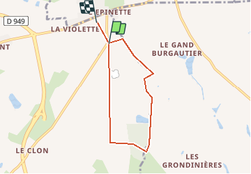
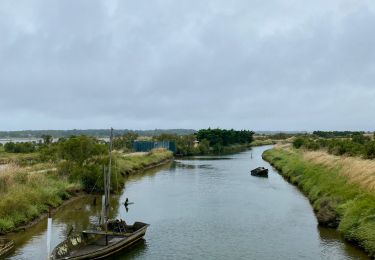
Tour Wandern von 5,8 km verfügbar auf Pays de la Loire, Vendée, Les Sables-d'Olonne. Diese Tour wird von Gregory Herlaud vorgeschlagen.
Beschreibung
Départ du parking circuit du karting du Coudriou.
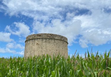
A voir : des chênes centenaires, un magnifique pin maritime.
Parcours pédestre et cyclable 5,6 km. Balisage en jaune.
Ort
Land:
France
Region :
Pays de la Loire
Abteilung/Provinz :
Vendée
Kommune :
Les Sables-d'Olonne
Standort:
Château-d'Olonne
Gehen Sie:(Dec)
Gehen Sie:(UTM)
600823 ; 5151457 (30T) N.
Kommentare
Touren in der Umgebung
![Tour Mountainbike Les Sables-d'Olonne - Pironnière vers le Veillon (le Cul d’Âne) - Photo](https://media.geolcdn.com/t/375/260/ext.jpg?maxdim=2&url=https%3A%2F%2Fmedia.geolcdn.com%2Ff%2F853eb98e-16c5-41f1-9677-bb9cf1715cef.jpeg)
![Mountainbike Mountainbike](https://static1.geolcdn.com/sitytour/trail-icons/202.png)
Pironnière vers le Veillon (le Cul d’Âne)
Mountainbike
Medium
(1)
Les Sables-d'Olonne,
Pays de la Loire,
Vendée,
France
![](/images/other/stat-length.png)
22 km | 25 km-effort
1h 58min
![](https://static1.geolcdn.com/siteimages/upload/files/16400158638029165_repeat_loop_refresh_sync_direction_icon.png)
Ja
![Tour Wandern Les Sables-d'Olonne - Orbestier Fradin les vallées - Photo](https://media.geolcdn.com/t/375/260/ext.jpg?maxdim=2&url=https%3A%2F%2Fstatic1.geolcdn.com%2Fsiteimages%2Fupload%2Ffiles%2F1553511878bg_sport_marche.png)
![Wandern Wandern](https://static1.geolcdn.com/sitytour/trail-icons/101.png)
Orbestier Fradin les vallées
Wandern
Einfach
(1)
Les Sables-d'Olonne,
Pays de la Loire,
Vendée,
France
![](/images/other/stat-length.png)
12,2 km | 13,3 km-effort
2h 48min
![](https://static1.geolcdn.com/siteimages/upload/files/16400158638029165_repeat_loop_refresh_sync_direction_icon.png)
Ja
![Tour Fahrrad Les Sables-d'Olonne - La Guittière - Photo](https://media.geolcdn.com/t/375/260/ext.jpg?maxdim=2&url=https%3A%2F%2Fstatic1.geolcdn.com%2Fsiteimages%2Fupload%2Ffiles%2F1524743154velo.jpg)
![Fahrrad Fahrrad](https://static1.geolcdn.com/sitytour/trail-icons/200.png)
La Guittière
Fahrrad
Einfach
(1)
Les Sables-d'Olonne,
Pays de la Loire,
Vendée,
France
![](/images/other/stat-length.png)
61 km | 67 km-effort
2h 40min
![](https://static1.geolcdn.com/siteimages/upload/files/16400158638029165_repeat_loop_refresh_sync_direction_icon.png)
Ja
![Tour Mountainbike Les Sables-d'Olonne - Pironniere vers Guittiere - Photo](https://media.geolcdn.com/t/375/260/ext.jpg?maxdim=2&url=https%3A%2F%2Fmedia.geolcdn.com%2Ff%2F8694f6ba-8cc9-4dfc-8eb1-683a8f63cab4.jpg)
![Mountainbike Mountainbike](https://static1.geolcdn.com/sitytour/trail-icons/202.png)
Pironniere vers Guittiere
Mountainbike
Schwierig
Les Sables-d'Olonne,
Pays de la Loire,
Vendée,
France
![](/images/other/stat-length.png)
30 km | 33 km-effort
2h 20min
![](https://static1.geolcdn.com/siteimages/upload/files/16400158638029165_repeat_loop_refresh_sync_direction_icon.png)
Ja
![Tour Mountainbike Les Sables-d'Olonne - Circuit du chemin de ronde - Photo](https://media.geolcdn.com/t/375/260/ext.jpg?maxdim=2&url=https%3A%2F%2Fmedia.geolcdn.com%2Ff%2Fc11f0a8f-51b5-4c8c-b979-de0e0728a76c.jpg)
![Mountainbike Mountainbike](https://static1.geolcdn.com/sitytour/trail-icons/202.png)
Circuit du chemin de ronde
Mountainbike
Medium
Les Sables-d'Olonne,
Pays de la Loire,
Vendée,
France
![](/images/other/stat-length.png)
20 km | 22 km-effort
2h 0min
![](https://static1.geolcdn.com/siteimages/upload/files/16400158638029165_repeat_loop_refresh_sync_direction_icon.png)
Ja
![Tour Mountainbike Les Sables-d'Olonne - Circuit Des Sauniers depuis la Pironiere - Photo](https://media.geolcdn.com/t/375/260/ext.jpg?maxdim=2&url=https%3A%2F%2Fmedia.geolcdn.com%2Ff%2F25dd4c19-8439-43c0-ba96-cec0bf780ec5.jpeg)
![Mountainbike Mountainbike](https://static1.geolcdn.com/sitytour/trail-icons/202.png)
Circuit Des Sauniers depuis la Pironiere
Mountainbike
Medium
Les Sables-d'Olonne,
Pays de la Loire,
Vendée,
France
![](/images/other/stat-length.png)
39 km | 42 km-effort
2h 56min
![](https://static1.geolcdn.com/siteimages/upload/files/16400158638029165_repeat_loop_refresh_sync_direction_icon.png)
Ja
![Tour Hybrid-Bike Les Sables-d'Olonne - Circuit des fermes - Photo](https://media.geolcdn.com/t/375/260/ext.jpg?maxdim=2&url=https%3A%2F%2Fstatic1.geolcdn.com%2Fsiteimages%2Fupload%2Ffiles%2F1524743154velo.jpg)
![Hybrid-Bike Hybrid-Bike](https://static1.geolcdn.com/sitytour/trail-icons/203.png)
Circuit des fermes
Hybrid-Bike
Einfach
Les Sables-d'Olonne,
Pays de la Loire,
Vendée,
France
![](/images/other/stat-length.png)
27 km | 29 km-effort
2h 0min
![](https://static1.geolcdn.com/siteimages/upload/files/16400158638029165_repeat_loop_refresh_sync_direction_icon.png)
Ja
![Tour Wandern Les Sables-d'Olonne - Les sables d’olonnes - Photo](https://media.geolcdn.com/t/375/260/ext.jpg?maxdim=2&url=https%3A%2F%2Fstatic1.geolcdn.com%2Fsiteimages%2Fupload%2Ffiles%2F1553511878bg_sport_marche.png)
![Wandern Wandern](https://static1.geolcdn.com/sitytour/trail-icons/101.png)
Les sables d’olonnes
Wandern
Les Sables-d'Olonne,
Pays de la Loire,
Vendée,
France
![](/images/other/stat-length.png)
6,3 km | 6,9 km-effort
1h 28min
![](https://static1.geolcdn.com/siteimages/upload/files/16400158638029165_repeat_loop_refresh_sync_direction_icon.png)
Nein
![Tour Wandern Les Sables-d'Olonne - Essai - Photo](https://media.geolcdn.com/t/375/260/ext.jpg?maxdim=2&url=https%3A%2F%2Fstatic1.geolcdn.com%2Fsiteimages%2Fupload%2Ffiles%2F1553511878bg_sport_marche.png)
![Wandern Wandern](https://static1.geolcdn.com/sitytour/trail-icons/101.png)
Essai
Wandern
Les Sables-d'Olonne,
Pays de la Loire,
Vendée,
France
![](/images/other/stat-length.png)
10,5 km | 11,3 km-effort
45min
![](https://static1.geolcdn.com/siteimages/upload/files/16400158638029165_repeat_loop_refresh_sync_direction_icon.png)
Nein